A map has been launched in Kyiv that shows the distance from the bus stop to the nearest shelter
Activists of the NGO "Passengers of Kyiv" created a map where you can see the distance from the "Kyivpastrans" stop to the nearest shelter.

Activists of the NGO "Passengers of Kyiv" created a map where you can see the distance from the "Kyivpastrans" stop to the nearest shelter.

Activists of the NGO "Passengers of Kyiv" created a map where you can see the distance from the "Kyivpastrans" stop to the nearest shelter.
To create the map, the coordinates of 2,739 Kyivpastrans stops and 4,047 shelters were used, and the distance between them was calculated, the public organization reports , emphasizing that this is a direct distance, so it may be longer on foot.
On the map , the stopping points are colored from green to red according to the distance to the shelter.
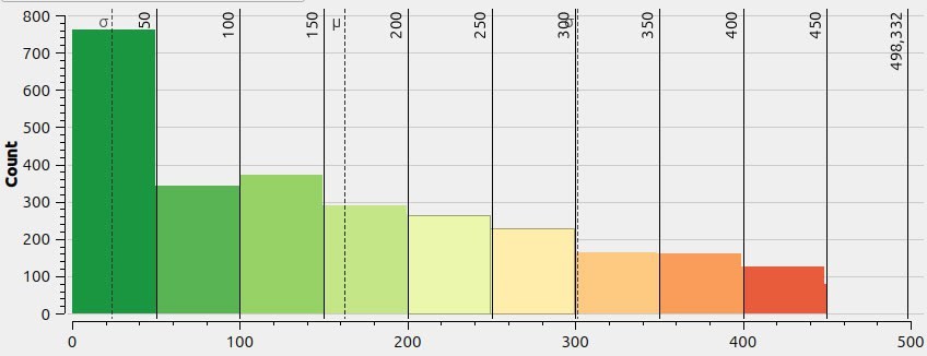
Those where the distance is more than 500 m are black, of which 600 were counted. Shelters that are located closer than 25 m from the stops are about 640. The average distance is 160 m.
"This map is made both for passengers who want to understand how far a shelter is from their stop, and for city authorities, who should take measures to arrange shelters close to the busiest stops," the activists noted.
You can also view the data in GeoJSON at the link .