Хочете будувати кар’єру в Data Science та AI? Vodafone Big Data Lab відкриває новий набір —>
Марія БровінськаStartup
24 September 2026, 16:15
2026-09-24
Aitivets created an app that notifies about air raid alerts in real time using a widget. Over the past four years, the app has been used by over a hundred thousand users.
Ukrainian developer Volodymyr Kovalchuk has been developing the application "Alarm Map of Ukraine. Widget" for four years, which allows you to learn about air threats in real time.
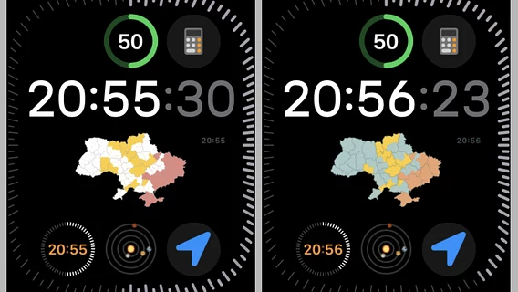
Today, the application allows you to add an alarm map to your home screen as a widget, choose a design style (map colors, region and district boundaries, appearance of different alarm states) and monitor the situation without unnecessary actions — including a version for Apple Watch, where you can view the map directly on your watch. The application is available on the App Store and Google Play .
The developer told dev.ua the story of the project, from the first version made a week ago at the beginning of the full-scale invasion, to the modern ecosystem with support for iPhone, iPad, Mac, and Apple Watch.
Ukrainian developer Volodymyr Kovalchuk has been developing the application "Alarm Map of Ukraine. Widget" for four years, which allows you to learn about air threats in real time.
Today, the application allows you to add an alarm map to your home screen as a widget, choose a design style (map colors, region and district boundaries, appearance of different alarm states) and monitor the situation without unnecessary actions — including a version for Apple Watch, where you can view the map directly on your watch. The application is available on the App Store and Google Play .
The developer told dev.ua the story of the project, from the first version made a week ago at the beginning of the full-scale invasion, to the modern ecosystem with support for iPhone, iPad, Mac, and Apple Watch.
An idea from the first weeks of the war
The story began in the first weeks of the full-scale invasion. Like millions of Ukrainians, Kovalchuk and his family hid during alarms, listening for sirens and explosions, and the telephone became one of the main sources of operational information.
The idea was suggested by Volodymyr’s wife — she said that it would be convenient to just look at the phone screen and immediately see the current situation with alarms, without the need to open a website or a separate application each time. At that time, Vadym Klymenko’s alarm map already existed, and later the alerts.in.ua service appeared, but Kovalchuk liked the idea of a map constantly available on the main screen of a smartphone.
About a week later, the first working version appeared: a widget that displayed an image of the current alarm map and updated it every 15–30 seconds. At first, only Kovalchuk’s family used the application, then friends and acquaintances. When it became clear that the product could be useful to a wider circle of people, he decided to make it public, free of charge, and with no plans to make money from it. The Android version was tested on Google Play in April 2022 and was released to all users in the summer, the iOS version appeared on the App Store in November 2022.
Smartphones instead of servers
Behind the outward simplicity — a widget with a map of Ukraine, where regions change color depending on the situation — was a rather unusual technical architecture. In the first versions, the map on the widget was a ready-made raster image that had to be regularly generated somewhere and delivered to users.
For this, a separate Android smartphone was used, which actually turned into a small specialized server: the application in the background opened the map via WebView, took a screenshot, processed the image, cleaned it of the background, compressed it, and sent it to the server, from where it was already received by regular user applications.
When widgets had different color schemes, the solution was straightforward—each scheme had a separate instance of the app running on a separate physical Android device. It looked exotic, but it allowed us to get the project up and running quickly without building a complex server-side graphics rendering system—and it worked well until the number of features, devices, and technical limitations started to grow.
Android, background work and phones
A separate challenge was the different behavior of Android devices from different manufacturers regarding background processes: what worked stably on one smartphone could stop updating on another due to more aggressive battery saving. The application had to be adapted to the specifics of specific manufacturers — often remotely, based on user descriptions and documentation, since Kovalchuk himself did not have the phone models on which the problem occurred.
Disappearing hosting sites and cyberattacks
Over the years of working on the project, we had to change hosting providers several times: one refused service due to the load from images (and, according to Kovalchuk, had a page on the Russian social network VKontakte), another — a European one — later went bankrupt. Several times, the servers were subjected to cyberattacks, after which part of the infrastructure had to be rebuilt — despite the fact that server administration is not Kovalchuk’s main specialization, who is a mobile developer by profession.
iOS: a different game with different rules
On iOS, the main problem was not the difference between manufacturers, but Apple’s tight control over background activity of applications — a developer cannot simply tell the system to run code every 30 seconds. For the alarm map, where the relevance of information is critical, this meant experimenting with different system mechanisms: a reaction to the activation of the device by the user, as well as optional geolocation, which in this scenario did not accumulate movement history, but performed a purely technical function — an additional trigger for background updates.
A separate constant compromise was the scheduling of background tasks between three factors: data relevance, OS limitations, and power consumption.
Switching to a vector map
Over time, the old architecture with ready-made images began to show the limits of its capabilities, and the physical impetus for the changes was the fact that Kovalchuk literally ran out of Android phones, which were used as the infrastructure for generating maps. The first experiments with a vector map began in early 2026, and in September there was a massive transition to a new implementation: the application no longer receives a ready-made image, but builds a map itself based on data on the state of the territories. This opened up more opportunities for customization and reduced the application’s traffic by more than 50 times.
Today, in the Android version, the user can customize the background color, colors of districts and areas depending on the threat level (separately for yellow and red) and enable the display of alarm reasons. A separate part of the functionality uses the API of the neptun.in.ua service, which allows tracking air targets in almost real time.
From a widget to a small ecosystem
The iOS version has also grown beyond the initial widget: there are now several widgets of different sizes, separate options for the lock screen and StandBy mode while charging, as well as an app for Apple Watch — to see the situation, the user just needs to look at their wrist. The iOS version can also be run on a MacBook.
How much does it cost and who uses it?
According to Kovalchuk, the project support cost an average of about UAH 1,500 per month, now the costs are slightly lower thanks to backend optimization. He initially counted his own development time, but then stopped, but in retrospect he estimates it as follows: about 20 hours for backend development, the same amount for server setup, and most of the time was taken up by mobile applications — about 350 hours for the Android version and about 300 hours for iOS.
At its peak, the app was recording about 100,000 users per week according to Firebase Analytics, now Google Play shows about 70,000 installations, and about the same number of updates in the App Store. The author notes that these metrics do not quite correctly reflect real usage: on Android, the app mostly runs in the background via a widget, and the user may hardly open the app itself.
Monetization is minimal: banner advertising was added about a year and a half after launch, and the revenue from it is about $100 in five to six months. Part of the costs is partially offset by voluntary donations from users. The costs are not limited to server rental — during the project’s existence, four Android smartphones that served as the infrastructure for generating maps failed, as well as two charging stations that supported this "infrastructure" during power outages.
Recently, the project has become a family project — Kovalchuk’s sons are participating in the development, combining it with their studies at the university: the eldest is involved in server setup and support, the youngest is in charge of the backend.
What’s next?
The main direction of development is the search for new APIs and reliable data sources that could improve user information about threats. The author emphasizes in principle: the application does not replace official air alert notification systems, but works as an additional information tool in parallel with them. Part of the functionality appeared thanks to feedback from users — in particular, integration with the Neptun API appeared.
Kovalchuk does not have a final list of features after which the project could be considered complete: as long as people need the application, he will continue to develop it.
Technical details According to the App Store, the application weighs 52.9 MB, supports Ukrainian and English languages, and is rated 4+. It requires iOS/iPadOS 15.0+ for iPhone and iPad, macOS 12.0+ on Macs with Apple Silicon chips, and watchOS 9.0+ for Apple Watch. The application is free, contains advertising, and optional purchases to support the developer — from "coffee" for $0.99 to "development energy" for $1.99.