UNIT.City — місце, де люди працюють... КРАЩЕ! Обирай свій простір просто зараз 👉
Олексій ДзюбаStartup
4 February 2025, 09:01
2025-02-04
"Maximize drone situational awareness to reduce losses." How startup Farsight Vision helps the military plan missions using terrain analysis
Viktoriya Yaremchuk, CEO and co-founder of Farsight Vision, has been working in the startup industry for almost 10 years. After the full-scale invasion began, she decided to create a company that would help our soldiers. This is how a device and platform were created that process media files received duringdrone footage and turn it into a 3D map of the area. This is not the only application of the Ukrainian startup's developments, which can be used in both military and civilian areas. We contacted Victoria Yaremchuk and talked about investments from Estonia, sales in Europe and the USA, why the startup needs a VR version and how she sees the future of the company.
Viktoriya Yaremchuk, CEO and co-founder of Farsight Vision, has been working in the startup industry for almost 10 years. After the full-scale invasion began, she decided to create a company that would help our soldiers. This is how a device and platform were created that process media files received duringdrone footage and turn it into a 3D map of the area. This is not the only application of the Ukrainian startup's developments, which can be used in both military and civilian areas. We contacted Victoria Yaremchuk and talked about investments from Estonia, sales in Europe and the USA, why the startup needs a VR version and how she sees the future of the company.
About founding a startup
— Tell us about your background. In one of the interviews I read that you graduated from the business school of UCU (Ukrainian Catholic University). How are you connected to startups?
— I have a diverse background. I wrote my thesis, taught, worked in IT, in management-related fields, and in non-IT companies. I liked studying at Lviv Business School not only because it is one of the best educational institutions, but also because of the networking and exchange of ideas. It was there that I met the co-founder of FarSight Vision, Volodymyr Nepiuk.
I've been involved in startups in various roles. For about 10 years, they were software startups. None of them were related to miltech or defense.
My startups were related to civil areas, these are logistics, automotive, fintech and health tech. From the latter niche, for example, there was a startup related to identifying markers of certain mental illnesses. I also worked in a company related to the automation of payment processes in healthcare in the USA. In general, these were startups focused on working in different states of America.
I have always tried to join startups that have a mission, that is, they help people in a valuable way. When the full-scale Russian invasion began, there was a feeling that I was not doing enough for Ukraine. Of course, there was some volunteer work, such as finding bulletproof vests, helmets, first-aid kits, etc. And while communicating with friends from the front, there was a feeling that I knew where I could help. It was an idea with 3D modeling and mapping of trenches. There was a request to understand the designs of enemy trenches in order to better plan your actions against the aggressor.
Photo — Victoria Yaremchuk
So we created a small prototype — we showed it to one part of the military. They approved it and named the improvements they would like. Meanwhile, other military personnel are asking to add other new features. The project gradually grew into a “little monster” (laughs). And here it is important that Volodymyr Nepiuk joined the startup as CTO. He has many years of experience in the technology sector. We decided to focus on helping our military with cartography, providing quick feedback on the territory and the ability to understand a completely unknown territory when there is no communication, not enough time and people.
— Yes, at the end of 2023, your startup FarSight Vision was founded with Volodymyr Nepiuk. There were two of you then. How many people are in the team now and what areas are they covering?
— Operations Manager Olga Rozumnyuk joined us. We have specialists in GIS (geoinformation systems), 3D, but these are not designers, but rather technological approaches to creating 3D modeling. In 3D, we have specialists from both Ukraine and Estonia. And if we talk about our positioning, then we can say that this is a Ukrainian-Estonian company. We also have specialists in Computer Vision, Machine Learning and AI. Plus specialists in building web platforms and mobile applications. We now have a hardware part, a web platform and are currently preparing a mobile application.
If we talk about the "core" of the team, then it is GIS, mathematicians, Data Analytics, Data Scientists and Digital Geodesy.
Since the product began to be used more widely in the defense sector — not only in the Armed Forces of Ukraine, but also in the National Guard, National Police, etc., communities began to gather around it. Thus, we have, so to speak, freelance advisors. They participate in various initiatives on a volunteer basis: both development and assistance to the military. The team currently has 25 specialists, 18 of whom are full-time.
DeepState in the world of demining. How a former GlobalLogic developer is using satellites, drones and neural networks to speed up land clearance in Ukraine
About investments
— In September 2024, you attracted 600,000 euros in investment from the Darkstar coalition, which was created by an Estonian and a great friend of Ukraine, Ragnar Sass. What did you spend the investment on?
— We are glad that they believed in us. The financial component is very important. But it is no less important that investors are involved and share their experience and network. Before Darkstar, we had investments from the Freedom Fund and two angel investors in the amount of $130,000 .
As for the funds from Darkstar, we have started spending them. The main focus is on R&D development, team expansion, support for our users and work with our brand abroad. We have also directed our efforts to participate in initiatives and grant programs of the EU, the UK, the USA, as there is a lot of interest there in joint projects, including strengthening their own defense capabilities.
Darkstar invested €600,000 in Ukrainian-Estonian battlefield intelligence startup Farsight Vision
— I read that the startup plans to have a seed round and raise up to $10 million this year. Your company is developing quite dynamically. What acceleration programs will you participate in and has anything changed in this direction?
— Our CTO Volodymyr says that we are moving at the speed of “one year in three” (laughs). Now we are starting to raise a new round, so I would stay with the previously announced figures. But they will be adjusted depending on how the raising goes.
Ukraine has developed a new method of mechanized mine clearance — using Starlink and not sensitive to enemy electronic warfare
About the product
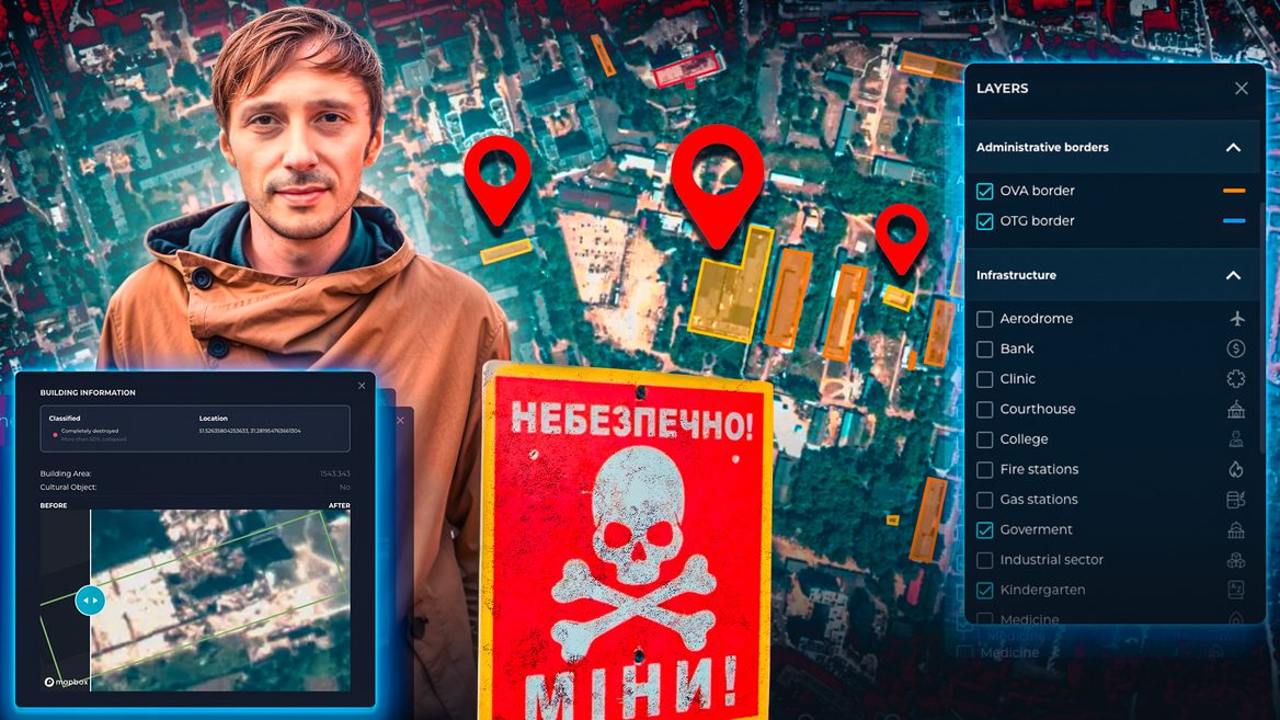
— Moving on to talking about your product. This is both hardware and software. There is the FSV Mapper device — it is used to pre-process media files obtained during drone filming. There is also the FSV Platform web platform, which converts this data into a 3D map of the area. Then the so-called digital twins are created. How does your solution work in practice?
— There are several options for the system to work. It can work as one common ecosystem or in conjunction with other products. We cooperate with defense businesses that produce UAVs. If the military uses other platforms, then we fully provide our module.
FSV Mapper is a device that can be used on the ground. It does not need to be flying. It works during post-processing. When the drone arrives, a map from the UAV is inserted into our device. There is also a version when the FSV Navigator is attached to the drone with or without additional cameras, depending on whether the drone has them. It is also important here whether there is an opportunity to transmit data in flight. There is also an option when the manufacturer immediately transmits the data to us on the platform. Then we can process them without our module.
After pre-processing on the platform, the data is tied to the map, to geographical coordinates. Because most flights take place in the active area of EW, or with the GPS module turned off, so that the drone is less noticeable. Thus, the data will not have a geographical reference and we "tie" them and provide georeferenced objects on the map.
Next, we show the “highlighted” objects on the digital twins and draw attention to the difference with the previous version. So when our users fly over an object for a certain time, they can automatically get “highlighted” changes in the territory - objects or landscape. This way they can immediately decipher what type of change it is. This saves a lot of time for analytics, planning and other purposes.
— How important is the detail of a 3D map for the military and what scale do you provide to clients?
— Accuracy is important, but it depends on various factors. In particular, on the quality of the camera and its stabilization. If the camera is stabilized but not fixed, it will be swayed by the wind, the camera angle may change, etc.
We aim and try to provide a scale of 4-7 cm/pixel.
For comparison, standard free satellite images give a size of several meters/pixel. If we talk about paid satellite images, which are provided by partners not daily, but for specific purposes, then there are indicators from 1 m to 15 cm/pixel.
— You mentioned the app. What stage of development is it at and what does it bring to the ecosystem of your products?
— We plan to use the mobile application on tablets or mobile phones, depending on the devices of our users. Because many systems were created specifically for use on tablets. This provides much better possibilities for caching fresh maps, providing information about certain changes, working with 3D, etc. It is inconvenient to take a laptop to the position when you already have so much equipment on you. A tablet or smartphone is more convenient in this sense.
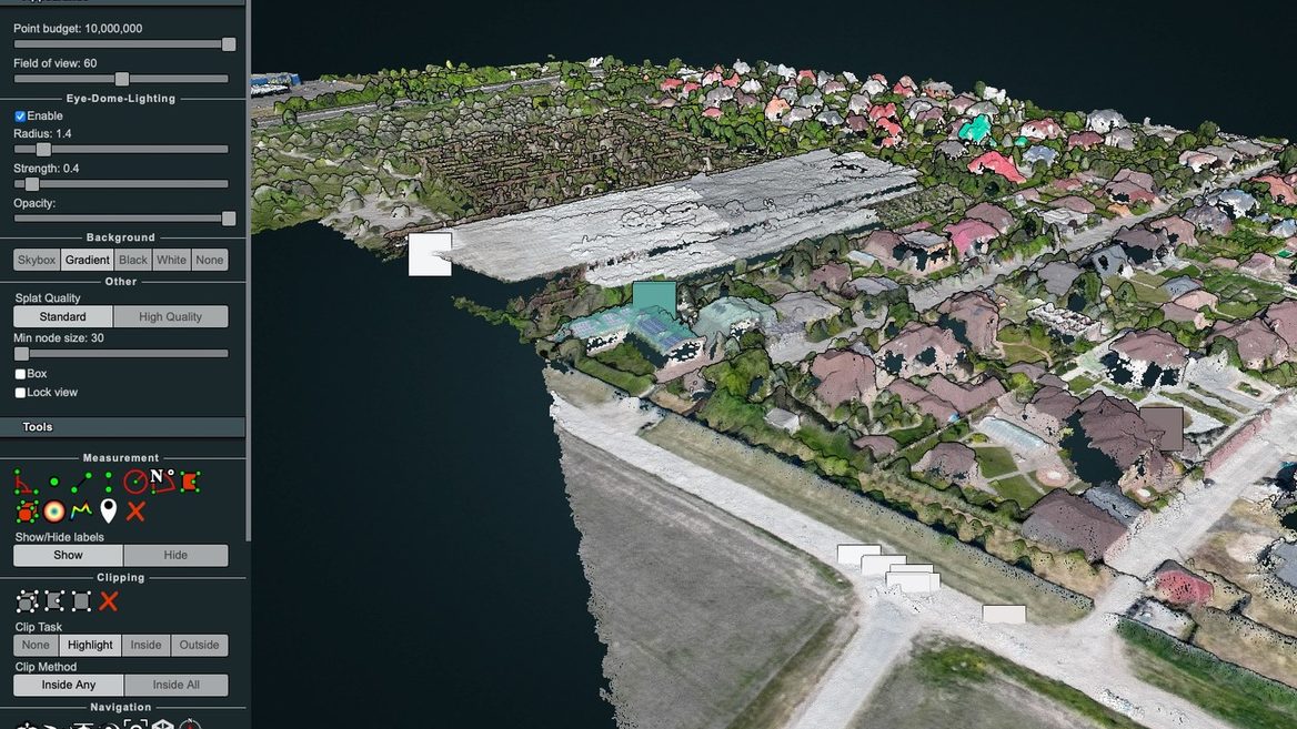
We also started exporting 3D models to VR headsets. You can actually "walk" around the area and understand what type of landscape it is, its features, and the nearest objects around.
Let's say a tree fell or something was dug up. Or where is your radio horizon or where is it better to organize ambushes. This is a completely different story in terms of quality, since this is a 3-dimensional space. We plan to release the application and provide VR services at the end of February.
— How many FSV Mapper do you produce per month and is the production located in Ukraine?
— For the needs of Ukraine, we manufacture in Ukraine. I won't say where exactly for security reasons.
We can now produce up to 1,000 units per month.
Photo –FSV Mapper
We also plan to expand production in Estonia a little. If the tests in America are successful, production in the USA is also possible.
— Can your development be used for demining?
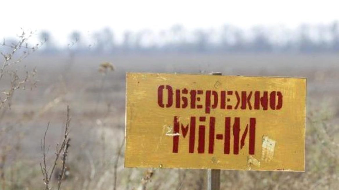
— Yes. We recently signed a memorandum of cooperation with the Humanitarian Demining Center. There are certain initiatives, both Ukrainian and from NATO countries, in which we are involved and where 3D modeling can be used to understand the height map and the ability of demining equipment to work. There is also an initiative to use 3D to find mines of a certain type.
Creator of "Free Video Translator" and founder of demining startup UADamage at Ukrainian Underdogs
About the company's development
— How can your development be used in the civilian sector?
— We work with a product of the so-called “dual use” (for civil and military spheres — ed.). The use of photogrammetry and 3D modeling is, among other things, civil history. It can be used in the agro-industry, logistics (planning and transportation), monitoring and tracking changes or violations of infrastructure (pipes, electricity, etc.). It is cheaper than in the EU, where helicopters or airplanes are used. In addition, such monitoring can be done more often.
Another application is within the work of the National Police. Namely, to prevent deforestation, poaching, etc. In the civilian sector, where there are GPs, there is an opportunity to work in "real time". We can also help with planning rescue operations due to natural disasters. Literally showing the geographical coordinates where help needs to be sent.
— Are you already making money from development and are you reinvesting the money you earn?
— In May 2024, the first sales appeared. We invest all the funds that come in into the product development. The model looks like this: we either sell FSV Mapper separately, or FSV Mapper and a license to use the platform. This is an annual license and you can get FSV Mapper components replaced up to a certain number of times.
Photo — The work of Farsight Vision
Now these are sales in the B2C format. So far we are not working with direct contracts and ministries, but we have applied for codification to the Ministry of Strategic Industry and are going through its first stages. We are one of those products for which there are no prescribed procedures. I think that the codification will be completed by the end of this year.
— Are you more focused on working in the West or in Ukraine?
— We started with the Ukrainian market. In the second half of 2024, we began to enter the Western European market.
We have a goal, at a minimum, to continue cooperation with the Baltic and Northern European countries (Norway, Denmark, Finland). There is interest from these countries, since Russia is also their neighbor.
In addition, there is interest from the UK in joint projects. We are also interested in Canada and the USA. But we have only just started communicating with clients in these countries. There, there is an emphasis on changing doctrines and approaches to innovation cycles. They reach three years, while for us it can be a few weeks. You can get into the civilian sector in the West faster, in the defense sector the contracting cycle can last 5-7 years.
— What do you see as the startup's prospects for this year?
— It is important for us to focus on several things. First of all, this is work with the detection and prediction of changes on maps. Therefore, we are actively investing in R&D and Data Science, building talents in this area. The second direction is 3D and scenario simulation and their presentation in VR. To provide drones with the maximum understanding of the landscape and situations on the ground to reduce losses.